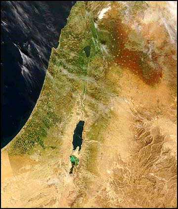
Probably the only country in the world where you can tell where the [political] border is even from space.
The snow on Mt. Hermon is also very neat on this picture.
I want to go back!!!
North Korea/South Korea at night is even clearer. There’s a *sharp* line where SK lights end and the darkness of NK begins.
Beautiful.
may i say, “yoffi”?
Ooh, interesting observation, Shadai. (also, weird to write that name out)
You’ve just written it out, too. Why is it weird?
“I am He who said to the world, ‘Enough!'”
Peep the visible Green Line: Proof of the Zionist axiom that we made the desert bloom.
No no, those orange groves and stuff were always there! Ever since before the time the King and Queen of Palestine used to wander amongst the populace, bearing witness to their happy subjects living in peace and prosperity far from the pernicious influence of the Zionist colonizers and uh… the totally useless Yeshivah students with their stupid Torah study.
Wow.
love this. its my new desktop image of the week.
Wow! I am sending it to my friend who is from Israel. I am saving it on my computer.


ooh, perty!
Probably the only country in the world where you can tell where the [political] border is even from space.
The snow on Mt. Hermon is also very neat on this picture.
I want to go back!!!
North Korea/South Korea at night is even clearer. There’s a *sharp* line where SK lights end and the darkness of NK begins.
Beautiful.
may i say, “yoffi”?
Ooh, interesting observation, Shadai. (also, weird to write that name out)
You’ve just written it out, too. Why is it weird?
“I am He who said to the world, ‘Enough!'”
Peep the visible Green Line: Proof of the Zionist axiom that we made the desert bloom.
No no, those orange groves and stuff were always there! Ever since before the time the King and Queen of Palestine used to wander amongst the populace, bearing witness to their happy subjects living in peace and prosperity far from the pernicious influence of the Zionist colonizers and uh… the totally useless Yeshivah students with their stupid Torah study.
Wow.
love this. its my new desktop image of the week.
Wow! I am sending it to my friend who is from Israel. I am saving it on my computer.